
Drone surveys for roofs, land and infrastructure
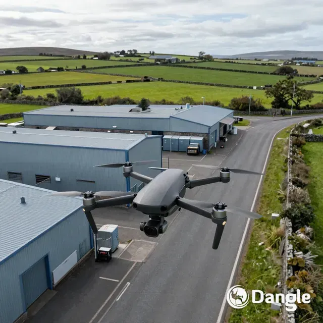
Drone surveys for roofs, land and infrastructure
A roof defect can be hard to assess from the ground, while reaching it in person may require careful access planning. Drone surveys capture images and data from roofs, land and infrastructure, helping teams inspect areas that are difficult to reach. Depending on the brief, the results may include imagery, mapped features or measurements.
It’s reasonable to expect more than a set of photographs. The capture method, coverage and deliverables affect whether information supports maintenance decisions or project planning. This guide explains how roof inspections work, what outputs to expect and how aerial inspection services can fit into a wider site plan.
You’ll also learn how photogrammetry and LiDAR suit different tasks, what can affect costs and turnaround, and how to assess a survey service’s approach to data capture, processing and site safety. Use these points to define what your survey needs to deliver before work begins.
Key Takeaways
- Match the capture method to the task: roof imagery, mapped building features and land measurements require different outputs.
- Use aerial capture to inspect hard-to-reach areas, while recognising when ground-based checks are still needed.
- Define the deliverables before the survey so the imagery, measurements or models support a clear operational decision.
- Assess a survey service by its capture plan, data processing, site safety and ability to explain the results clearly.
- For defects that need hands-on inspection or repair, consider how specialist access services can support the next stage of work.
Table of Contents
- Are drones good for roof inspections?
- What is a Drone Survey?
- Aerial data capture for land, buildings and infrastructure
- Survey deliverables and post-processing
- Choosing a drone surveying service
- Dangle®: Industrial Rope Access Services
Are drones good for roof inspections?
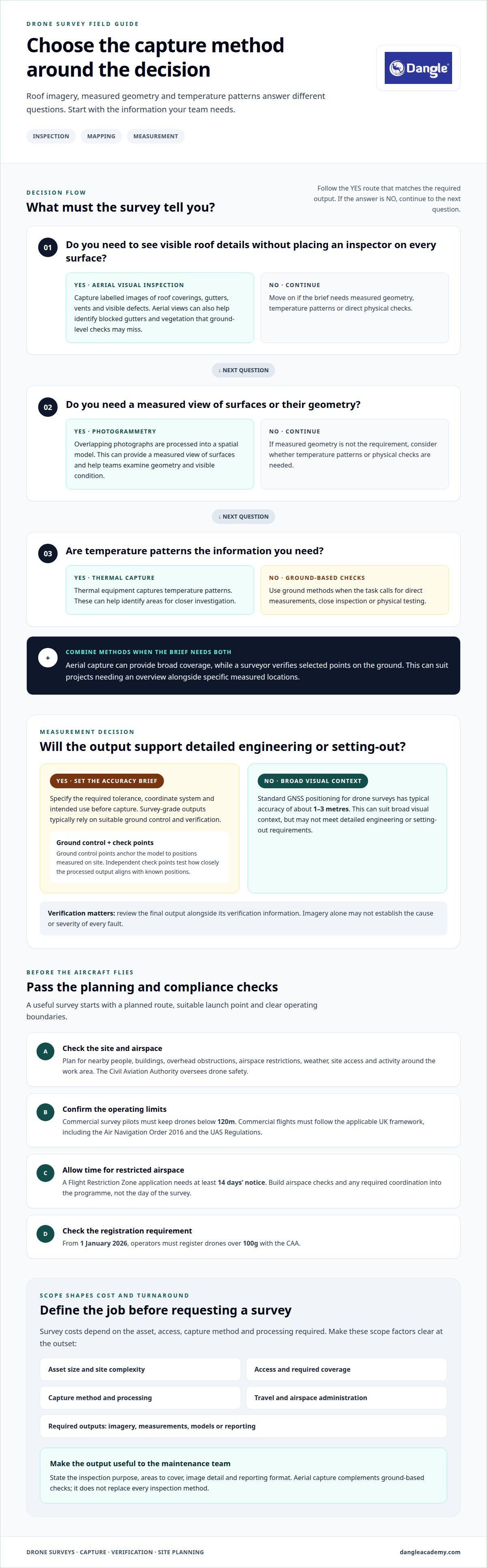
Yes. Aerial inspections can capture roof details without placing an inspector directly on every surface. They can help identify visible defects, blocked gutters and vegetation that ground-level checks may miss.
Flight Planning and Permissions
Before flight, pilots plan the inspection area, launch point, route and required outputs. They assess nearby people, buildings, overhead obstructions and airspace restrictions. In the UK, commercial survey flights must follow the applicable framework. According to UK legislation, this includes the Air Navigation Order 2016 and the UAS Regulations. The Civil Aviation Authority oversees drone safety.
Flight requirements depend on the operation and location. In Northern Ireland, we check the applicable UK CAA flight and airspace guidance and confirm any site-specific permissions before scheduling. For work in the Republic of Ireland, we check Irish Aviation Authority airspace restrictions and the requirements for the planned operation. Site access, weather and nearby activity also shape the flight plan.
At a warehouse, a planned route can cover roof edges, vents and gutters while avoiding busy entrances. Drone surveys can reduce the need to send staff into hazardous areas and avoid some scaffolding or cherry-picker preparation. The pilot still needs a safe launch area, clear operating boundaries and a plan for people moving around the site.
Bridge inspections need extra planning because traffic, water, wind and restricted launch positions can affect the operation. Drone surveys can capture bridge decks, parapets and structural faces from planned viewpoints. The flight plan must account for vehicles and pedestrians below. For example, the site team can coordinate access boundaries and inspection timing before the aircraft approaches a live road or waterway.
Cost and Compliance Considerations
Survey costs depend on the asset’s size, access, coverage, capture method and processing requirements. Site complexity, travel, airspace administration and the required outputs all affect the scope. A visual roof check calls for different processing from measured photogrammetry or thermal inspection.
Compliance planning also affects the work programme. Restricted airspace may require advance coordination, while a congested site can need a more controlled operating area. Where permission is needed, we check the lead time with the relevant authority when planning the survey. Specify the asset, inspection purpose and deliverables early, so the plan reflects the actual task.
Useful roof outputs include labelled images of roof coverings, gutters, vents and visible defects. Photogrammetry can provide a measured view of surfaces, but imagery alone cannot establish the cause or severity of every fault. A report should distinguish visible evidence from interpretation, especially when maintenance decisions depend on hidden layers or close physical examination.
Aerial capture is most useful when it answers a defined question, such as locating damaged cladding before arranging access equipment. It complements ground-based checks rather than replacing every inspection method. Set out the required areas, image detail and reporting format before the flight. This gives the pilot a clear capture plan and makes the results more useful to maintenance teams.
What is a Drone Survey?
A drone survey uses an unmanned aircraft to collect aerial imagery or spatial data for inspection, mapping and measurement. The intended output shapes the capture plan, equipment and processing. A visual record of a building façade, for example, requires different information from a model used to assess site levels.
Drone and Ground-Based Methods
For building surveys, aerial capture can document rooflines, façades and other features from planned viewpoints. Photogrammetry processes overlapping photographs into a spatial model, allowing teams to examine geometry and visible condition. Thermal equipment captures temperature patterns instead, which can help identify areas for closer investigation.
Ground-based methods remain useful for direct measurements, close inspection and physical testing. A surveyor can measure selected points with ground equipment, while a close-range inspection can reveal surface texture that photographs may not resolve. The key decision is how much detail you need and how the information will be used.
Combining aerial and ground methods can provide broad coverage alongside verified site measurements. For example, drone surveys can map a development area while a surveyor verifies selected boundary or asset points on the ground. This hybrid approach is useful when a project needs both an overview and specific measured locations.
Accuracy and Verification
Accuracy depends on positioning, image quality, site conditions and processing. Standard GNSS positioning for drone surveys has typical accuracy of about 1-3 metres. That can suit broad visual context, but may not meet the requirements for detailed engineering or setting-out. Define the required tolerance before capture.
Survey-grade outputs typically rely on suitable ground control and verification. Ground control points are identifiable positions measured on site and matched to captured imagery during processing. Their distribution helps anchor the model across the survey area. Independent check points can then test how closely the processed output aligns with known positions.
Before capture, specify the coordinate system, accuracy requirement and intended use. A boundary review, construction record and measured building model each call for different information. The capture team can plan image overlap and control placement around those requirements, rather than collecting imagery without a clear measurement brief.
Review the final output alongside its verification information. For example, a team comparing construction phases needs a consistent reference between each record. If mapped findings lead to close inspection or physical work, an inspection and site services plan can connect aerial observations with practical follow-up.
Aerial data capture for land, buildings and infrastructure
Aerial capture uses drone technology to record land, buildings and infrastructure from planned viewpoints. It is also called an aerial survey or unmanned aerial vehicle (UAV) survey. Depending on the brief, it can produce imagery, mapped features and surface models. A land development plan, for example, may need elevations and terrain detail, not just photographs.
For buildings, photogrammetry processes overlapping images into a digital representation of visible surfaces. For topographical land work, LiDAR can capture terrain and elevation data. The right method depends on the site and intended use. A project team planning an extension may need ground levels and boundaries, while a facilities team may need a visual record of roof or façade condition.
Construction teams can use LiDAR or photogrammetry to support cut-and-fill calculations. A survey can measure a stockpile against a baseline and calculate its cubic volume. Comparing a current capture with an earlier survey can also quantify earth movements. These comparisons provide site managers with a consistent record of how a defined area has changed during construction.
For expansion planning, define the survey boundary before the flight. Include adjoining areas if access routes, drainage or proposed works cross the main site edge. A topographical output can show elevations and surface features within the captured area, helping designers assess how a proposed layout relates to existing ground. It records surveyed conditions but does not establish legal ownership or boundary rights.
Agree data ownership and usage rights in the project scope before capture. Specify who receives the original imagery, processed files and final reports, and whether the data can be reused for later design or monitoring. For example, a contractor and asset owner may both need access to a construction progress model. Clear terms prevent confusion over permitted use and responsibility for storing project records.
Plan how site teams will access the outputs. Name the file formats, coordinate reference, delivery method and intended users in the brief. A site manager reviewing earthworks may need a surface model and volume report, while a designer may need mapped elevations for CAD or GIS workflows. Confirming these requirements before processing helps the data fit existing project systems.
Fieldwork and processing times depend on the size of the survey area, the capture method and the outputs required. Processing converts captured data into usable outputs, such as orthomosaic imagery, terrain models or measured features. For ongoing construction monitoring, repeat captures can be compared with earlier records. This creates a practical sequence for tracking progress, checking changes and supporting maintenance planning across an asset or estate.
Survey deliverables and post-processing
The value of aerial capture depends on what the project team receives and how it can use the results. Agree on the deliverables, file format and reporting purpose before the flight. A facilities manager reviewing roof condition needs different outputs from a designer measuring a development site.
What the deliverables can include
A visual inspection may provide high-resolution photographs organised by asset area, such as roof slope, elevation or bridge component. Annotated images can identify observed defects and show their position. Clear labels help maintenance teams connect each image with the relevant part of the asset instead of searching through an unstructured folder.
Mapping and measurement projects can produce orthomosaic imagery, surface models, point clouds or measured features. Each output supports different workflows. For example, a site manager tracking earthworks may need a surface model, while an engineer may need measured geometry for design coordination. Request the deliverable that supports the decision, not simply “all survey data”.
File formats and practical access
File format affects whether the output opens in the software your project team already uses. Confirm whether users need image files, a PDF report, CAD-compatible drawings, GIS data or a three-dimensional model. Agree on the coordinate reference and naming convention too. A consistent structure helps teams compare captures and store records against the correct building or infrastructure asset.
Set out who needs access and how files will be transferred. A site-based team may need a concise report and selected images, while a design team may need the underlying model for further analysis. Specify whether the deliverables are for desktop review, shared project storage or field access. Large datasets can be difficult to use on site without a prepared viewing method.
Post-processing and turnaround
Processing turns raw capture into usable outputs. The workflow may include image alignment, reconstruction, quality review, measurement and report preparation. For a roof inspection, the reviewer can group images by roof area and flag visible damage. For a construction record, the processor can prepare mapped outputs to support comparison with project drawings.
We confirm turnaround and any expedited delivery costs once the survey scope, site constraints and required outputs are agreed. Processing complexity, required checks and output type all influence the programme. Agree on a delivery date that supports the decision, such as a maintenance review or design meeting.
Before accepting the final files, confirm that they open correctly and include the agreed coverage. Check image labels, coordinate information and report references. For ongoing monitoring, use the same naming and delivery structure for each capture. Consistent records make changes easier to compare and support future inspection planning.
Choosing a drone surveying service
UK industries using aerial surveys include construction, property, utilities, transport and infrastructure. In Belfast and across Northern Ireland, projects may involve specialist aerial inspection operators, geospatial consultancies and surveying firms. Services can include visual inspections, topographical mapping and measured digital outputs.
Start with the decision the survey must support. A facilities manager checking roof condition needs clear, labelled imagery. A construction manager tracking ground movement needs comparable site data. A designer planning an extension may need elevations and a defined survey boundary. Ask for a detailed scope that connects the capture method to the intended use.
Check that the proposed method suits the site. Photogrammetry uses overlapping images to create mapped outputs, while LiDAR captures spatial information about terrain and structures. Thermal capture serves a different purpose from standard visual imagery. The provider should explain why its equipment and processing approach suit your asset, access conditions and accuracy requirements.
Review the flight plan before work starts. It should identify the survey area, launch and landing arrangements, nearby people, obstacles and relevant airspace constraints. For example, a utilities site beside a public road needs a plan that accounts for traffic and site activity. Clear coordination helps the survey team capture the required areas safely.
Ask how the team verifies its outputs. For measured work, find out whether ground control and independent checks support the processed data. Review a sample report or model to see how features are labelled and findings presented. A digital file is useful only if your team can interpret it and apply it in its existing project workflow.
Clarify responsibility for site access, data handling and liability. Agree who supplies site information, who receives the raw imagery and processed files, and how each party may use the results. For a building portfolio, specify whether the owner, facilities team and design consultant all need access. A written scope prevents misunderstandings about deliverables and permitted use.
Compare quotations by scope, not just by headline price. Survey area, asset complexity, airspace administration, travel, processing and reporting all affect the work involved. A visual roof check differs substantially from a measured topographical survey. Request a breakdown of capture, processing, deliverables and site-specific requirements.
Finally, confirm the delivery schedule against your project dates. Before appointing a provider, align the required output, flight plan, data format and decision deadline. This gives the survey a clear purpose and makes the results easier to act on.
Dangle®: Industrial Rope Access Services
Dangle® provides Industrial Rope Access Services for inspection and maintenance tasks on hard-to-reach structures. Aerial imagery can help identify areas for follow-up, but close inspection or physical work may still require IRATA-qualified technicians at the asset. Rope access can support that next stage, including work on industrial structures and wind turbines.
For wind turbine assets, Dangle® also provides Wind Turbine Blade Repair. If your priority is developing workforce capability, its training includes IRATA Rope Access Training (All Levels) and GWO Advanced Rescue Training (ART). The right route depends on whether you need site work, specialist repair or training.
Use the survey findings to define the asset, access challenge and required work. Contact Dangle® to discuss the next step for your project.
Turn survey findings into a practical next step
Before commissioning work, define the decision your survey must support and who will use the results. A clear brief aligns the scope with the asset, areas to capture and format your team can use. It also gives everyone a shared reference for assessing the final outputs.
For drone surveys that lead to further site work, consider the next operational step alongside data capture. Dangle® can discuss how its industrial services may suit your project, from initial findings through to planning follow-up work.
Share your asset type, survey area and intended use to start a focused discussion. Contact Dangle® about your survey requirements and plan the next step with confidence.
Drone Survey Frequently Asked Questions
Can you fly in cities, near airports or around people?
Yes, flights can take place in these settings when the operation suits the site and airspace. A city-centre project should account for public access, neighbouring properties and safe launch and landing areas. Near an airport, airspace restrictions may affect whether and when a flight can proceed. Give the operator the site address and inspection purpose early so these constraints can shape the plan.
Is LiDAR or photogrammetry better for my project?
Choose the method that provides information your team can act on. For example, a property team documenting visible façade changes may prioritise clear visual records. A designer assessing ground shape may need data suited to terrain analysis. Before deciding, state how the output will be used, who will interpret it and whether it must fit existing design or asset-management software.
What equipment is needed?
The aircraft needs a sensor suited to the task, such as a standard imaging camera, thermal sensor or LiDAR unit. Survey work may also require positioning equipment and ground control targets. The processing workflow matters too: captured files need suitable software and a defined output specification. For a facility inspection, agree which assets and views matter before selecting equipment, rather than choosing a sensor first.
What are drone surveys and what are they used for?
Drone surveys are aerial data-capture projects used to inspect, map or record assets. They can document a building before nearby construction, track progress across a development site and create records for future maintenance planning. A project manager might commission repeat captures to compare site conditions over time. The brief should state the decision the information must support, such as prioritising repairs or recording completed work.
How much do drone surveys cost in the UK?
There isn’t one UK-wide price that suits every project. For a useful budget, compare quotations against the same written scope and check whether each includes capture, processing, reporting, travel and airspace administration. Distinguish a visual inspection from measured outputs or specialist sensor work too. This helps show whether a lower quotation covers the deliverables your team needs, rather than a shorter capture task.
What UK drone rules and CAA permissions apply to commercial surveys?
For a commercial survey in Northern Ireland, the applicable UK CAA requirements depend on the operation and location. If the site is within an aerodrome’s Flight Restriction Zone, we obtain permission from the relevant authority before flying. The flight plan also accounts for people, obstacles and local airspace restrictions. For work in the Republic of Ireland, we check Irish Aviation Authority requirements separately.
What types of drone surveys are available, including photogrammetry and LiDAR?
Common options include visual asset inspections, photogrammetry, LiDAR mapping and thermal capture. Each produces different information, so specify whether your team needs photographs, a mapped surface, terrain data or temperature-pattern imagery. A construction manager might need progress records, while a building owner may need a visual condition file. Some projects combine outputs for operational and design teams.
How accurate are drone surveys compared with traditional land surveys?
Aerial surveys are not automatically interchangeable with ground measurements. Accuracy depends on the required output, positioning method, control, capture conditions and verification. Ground-based surveying can provide direct measurements at selected points, while aerial capture covers broader areas. For a design decision, define the required tolerance and coordinate reference first, then assess whether aerial data alone or a combined survey approach can meet the specification.
Contact Us
We'd Love a Share...
Recent Blog Posts


